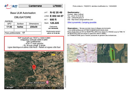


LF6660 - Canterrane
Located in Terrats, France
ICAO - , IATA -
Data provided by AirmateGeneral information
Coordinates: N42°35'49" E2°44'7"
Elevation is 600 feet MSL.
View others Airports in Languedoc-Roussillon
Operational data
Special qualification required
Current time UTC:
Current local time:
Weather at : LFMP - Perpignan Rivesaltes ( 19 km )
METAR: LFMP 291030Z AUTO 32011KT 290V010 CAVOK 26/11 Q1016 NOSIG
TAF: TAF LFMP 290800Z 2909/3009 32010KT CAVOK BECMG 3007/3009 30015G25KT FEW045TCU
Communications frequencies: [VIEW]
Runways:
| RWY identifier | QFU | Length (ft) | Width (ft) | Surface | LDA (ft) |
| 17 | 0° | 754 | 98 | GRASS | |
| 35 | 0° | 754 | 98 | GRASS |
Airport contact information
Address: Terrats France