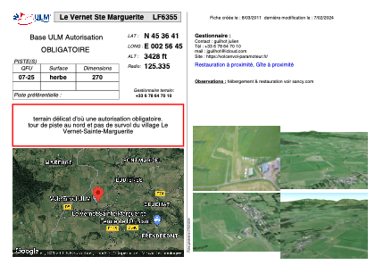


LF6355 - Le Vernet Ste Marguerite
Located in Le Vernet-Sainte-Marguerite, France
ICAO - , IATA -
Data provided by AirmateGeneral information
Coordinates: N45°36'41" E2°56'45"
Elevation is 3428 feet MSL.
View others Airports in Limousin
Operational data
Special qualification required
Current time UTC:
Current local time:
Weather at : LFLC - Clermont Ferrand Auvergne ( 26 km )
METAR: LFLC 160030Z AUTO 22004KT 190V260 9999 FEW041 SCT049 BKN058 13/09 Q1014 NOSIG
TAF: TAF LFLC 152300Z 1600/1624 18008KT 9999 SCT045 BECMG 1609/1611 24010KT TEMPO 1611/1615 25015G25KT BECMG 1620/1622 VRB03KT
Communications frequencies: [VIEW]
Runways:
| RWY identifier | QFU | Length (ft) | Width (ft) | Surface | LDA (ft) |
| 07 | 0° | 885 | 0 | GRASS | |
| 25 | 0° | 885 | 0 | GRASS |
Airport contact information
Address: Le Vernet-Sainte-Marguerite France