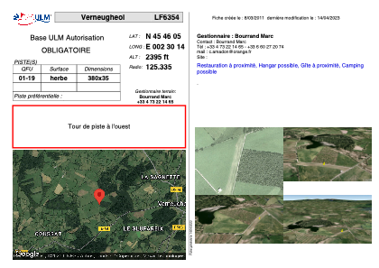


LF6354 - Verneugheol
Located in Verneugheol, France
ICAO - , IATA -
Data provided by AirmateGeneral information
Coordinates: N45°46'5" E2°30'14"
Elevation is 2395 feet MSL.
View others Airports in Limousin
Operational data
Special qualification required
Current time UTC:
Current local time:
Weather at : LFLC - Clermont Ferrand Auvergne ( 51 km )
METAR: LFLC 290930Z AUTO 18003KT 140V220 CAVOK 16/12 Q1018 TEMPO RA
TAF: TAF LFLC 290500Z 2906/3006 VRB02KT CAVOK BECMG 2907/2909 18005KT TEMPO 2907/2912 RA TEMPO 2922/3006 RA BKN030
Communications frequencies: [VIEW]
Runways:
| RWY identifier | QFU | Length (ft) | Width (ft) | Surface | LDA (ft) |
| 01 | 0° | 1246 | 114 | GRASS | |
| 19 | 0° | 1246 | 114 | GRASS |
Airport contact information
Address: Verneugheol France