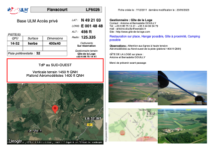


LF6026 - Flavacourt
Located in Flavacourt, France
ICAO - , IATA -
Data provided by AirmateGeneral information
Coordinates: N49°21'3" E1°48'48"
Elevation is 456 feet MSL.
View others Airports in Upper Normandy
Operational data
Special qualification required
Current time UTC:
Current local time:
Weather at : LFOB - Beauvais Tille ( 25 km )
METAR: LFOB 152130Z AUTO 20008KT 9999 FEW013/// SCT046/// BKN056/// ///TCU 13/11 Q1007 TEMPO 3000 SHRA BKN012 BKN020TCU
TAF: TAF LFOB 151700Z 1518/1618 23010KT 9999 BKN030 TEMPO 1518/1524 3000 SHRA BKN012 BKN020TCU PROB30 TEMPO 1518/1520 1500 TSRA SCT008 BKN012 BKN020CB TEMPO 1600/1610 BKN008 BKN012 PROB30 TEMPO 1605/1610 3000 -RA TEMPO 1610/1618 VRB15G25KT 3000 SHRA SCT013 BKN020TCU
Communications frequencies: [VIEW]
Runways:
| RWY identifier | QFU | Length (ft) | Width (ft) | Surface | LDA (ft) |
| 14 | 0° | 1312 | 131 | GRASS | |
| 32 | 0° | 1312 | 131 | GRASS |
Airport contact information
Address: Flavacourt France