


LF5753 - Rémeling
Located in Rémeling, France
ICAO - , IATA -
Data provided by AirmateGeneral information
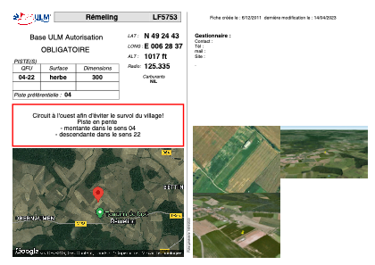
Coordinates: N49°24'43" E6°28'37"
Elevation is 1017 feet MSL.
View others Airports in Lorraine
Operational data
Special qualification required
Current time UTC:
Current local time:
Weather at : ELLX - Luxembourg ( 31 km )
METAR: ELLX 151450Z 22014KT CAVOK 16/05 Q1009 TEMPO 22015G25KT
TAF: TAF ELLX 151100Z 1512/1618 23015G25KT 9999 SCT040 BECMG 1515/1517 22010KT PROB30 TEMPO 1519/1603 20015G25KT SHRA BKN013TCU TEMPO 1603/1610 BKN009 PROB40 TEMPO 1611/1615 SHRA BKN012TCU
Communications frequencies: [VIEW]
Runways:
| RWY identifier | QFU | Length (ft) | Width (ft) | Surface | LDA (ft) |
| 04 | 0° | 984 | 0 | GRASS | |
| 22 | 0° | 984 | 0 | GRASS |
Airport contact information
Address: Rémeling France