VAC chart of LF4453
Satellite view of LF4453
image banner adimage banner adimage banner ad
image banner ad

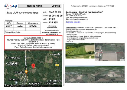
LF4453 - Nantes Héric

Located in Héric, France

ICAO - , IATA -

Data provided by Airmate  

General information

Coordinates: N47°23'9" W1°38'8"
Elevation is 110 feet MSL.
 
View others Airports in Pays-de-la-Loire

Operational data

Special qualification required
Current time UTC:
Current local time:
Weather at : LFRS - Nantes Atlantique ( 26 km )
METAR: LFRS 152230Z AUTO 23007KT 9999 BKN026 BKN032 OVC052 14/13 Q1009 BECMG 4000 -RA BKN007 BKN015
TAF: TAF AMD LFRS 151828Z 1518/1624 24014KT 9999 SCT020 BKN040 TEMPO 1518/1521 24015G25KT 4000 SHRA BKN008 BKN018TCU BECMG 1523/1601 18010KT 4000 -RA BKN007 BKN015 TEMPO 1601/1604 2500 RA BKN004 BKN012 FM160400 26008KT 9999 BKN030 PROB40 TEMPO 1610/1614 4000 SHRA BKN015TCU BECMG 1614/1617 20010KT 4000 -RA BKN012 BKN020 TEMPO 1617/1624 2500 RA BKN004 OVC012
View NOTAMs / SUP AIP / TFR affecting this airport [VIEW]
Communications frequencies: [VIEW]

Runways:

RWY identifierQFULength (ft)Width (ft)SurfaceLDA (ft)
09104998GRASS
27104998GRASS

Airport contact information

Address: Héric France

Satellite view of LF4453