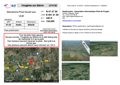


LF4128 - Fougères sur Bièvre
Located in Fougères-sur-Bièvre, France
ICAO - , IATA -
Data provided by AirmateGeneral information
Coordinates: N47°27'30" E1°21'59"
Elevation is 335 feet MSL.
View others Airports in Centre
Operational data
Special qualification required
Current time UTC:
Current local time:
Weather at : LFYR - Romorantin Pruniers ( 29 km )
METAR: LFYR 140900Z AUTO 26009KT 220V290 9999 SCT027 BKN036 BKN100 18/13 Q1010 TEMPO BKN007
TAF: TAF LFYR 140800Z 1409/1509 22005KT 9999 BKN025 TEMPO 1409/1411 BKN007 TEMPO 1411/1501 22015G30KT 4000 SHRA BKN020TCU PROB40 TEMPO 1500/1503 30020G35KT
Communications frequencies: [VIEW]
Runways:
| RWY identifier | QFU | Length (ft) | Width (ft) | Surface | LDA (ft) |
| 07 | 0° | 1968 | 98 | GRASS | |
| 25 | 0° | 1968 | 98 | GRASS |
Airport contact information
Address: Fougères-sur-Bièvre France