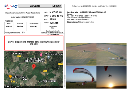


LF3767 - La Canté
Located in Descartes, France
ICAO - , IATA -
Data provided by AirmateGeneral information
Coordinates: N47°0'40" E0°40'16"
Elevation is 229 feet MSL.
View others Airports in Centre
Operational data
Special qualification required
Current time UTC:
Current local time:
Weather at : LFOT - Tours Val De Loire ( 47 km )
METAR: LFOT 111200Z AUTO 30005KT 250V350 CAVOK 19/07 Q1018 NOSIG
TAF: TAF LFOT 111111Z 1112/1212 01006KT 9999 FEW045 SCT060 PROB40 TEMPO 1116/1120 33010G20KT -SHRA FEW050TCU BKN060
Communications frequencies: [VIEW]
Runways:
| RWY identifier | QFU | Length (ft) | Width (ft) | Surface | LDA (ft) |
| 03 | 0° | 656 | 262 | GRASS | |
| 21 | 0° | 656 | 262 | GRASS |
Airport contact information
Address: Descartes France