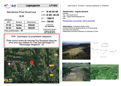


LF1952 - Lagleygeolle
Located in Lagleygeolle, France
ICAO - , IATA -
Data provided by AirmateGeneral information
Coordinates: N45°4'49" E1°40'24"
Elevation is 1380 feet MSL.
View others Airports in Limousin
Operational data
Special qualification required
Current time UTC:
Current local time:
Weather at : LFSL - Brive Souillac ( 15 km )
METAR: LFSL 290830Z AUTO 19004KT 9999 -RA FEW031/// BKN100/// //////CB 16/12 Q1019 BECMG BKN030
TAF: TAF LFSL 290800Z 2909/2918 28005KT CAVOK BECMG 2910/2912 BKN030 TEMPO 2912/2918 4000 -RA BKN015 TEMPO 2916/2918 3000 -RADZ BKN009
Communications frequencies: [VIEW]
Runways:
| RWY identifier | QFU | Length (ft) | Width (ft) | Surface | LDA (ft) |
| 07 | 0° | 1410 | 65 | GRASS | |
| 25 | 0° | 1410 | 65 | GRASS |
Airport contact information
Address: Lagleygeolle France