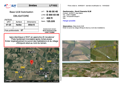


LF1652 - Brettes
Located in Villefagnan, France
ICAO - , IATA -
Data provided by AirmateGeneral information
Coordinates: N46°0'40" E0°3'9"
Elevation is 400 feet MSL.
View others Airports in Poitou-Charentes
Operational data
Special qualification required
Current time UTC:
Current local time:
Weather at : LFBU - Angouleme Brie Champniers ( 34 km )
TAF: TAF LFBU 101700Z 1018/1118 30010KT 9999 BKN030 PROB30 TEMPO 1101/1106 4000 -RA BKN008 BECMG 1102/1104 01005KT PROB40 TEMPO 1107/1115 4000 -SHRA BKN035TCU PROB30 TEMPO 1110/1113 02015G30KT
Communications frequencies: [VIEW]
Runways:
| RWY identifier | QFU | Length (ft) | Width (ft) | Surface | LDA (ft) |
| 07 | 0° | 1148 | 49 | GRASS | |
| 25 | 0° | 1148 | 49 | GRASS |
Airport contact information
Address: Villefagnan France