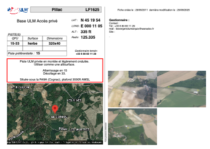


LF1625 - Pillac
Located in Pillac, France
ICAO - , IATA -
Data provided by AirmateGeneral information
Coordinates: N45°19'54" E0°11'5"
Elevation is 335 feet MSL.
View others Airports in Aquitaine
Operational data
Special qualification required
Current time UTC:
Current local time:
Weather at : LFBU - Angouleme Brie Champniers ( 44 km )
METAR: LFBU 291030Z AUTO 20007KT 160V230 6000 -RA BKN012/// BKN017/// BKN022/// ///TCU 15/13 Q1018 TEMPO 3000 RA BKN005
TAF: TAF AMD LFBU 290811Z 2908/3006 18005KT 9999 BKN020 TEMPO 2909/3006 3000 RA BKN005 TEMPO 2921/3004 1000 RADZ BKN002
Communications frequencies: [VIEW]
Runways:
| RWY identifier | QFU | Length (ft) | Width (ft) | Surface | LDA (ft) |
| 15 | 0° | 1049 | 131 | GRASS | |
| 33 | 0° | 1049 | 131 | GRASS |
Airport contact information
Address: Pillac France