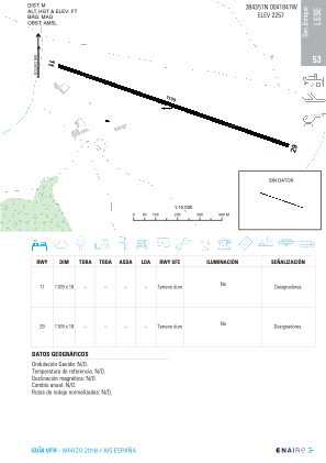


LESE - San Enrique (Ciudad Real)
Located in Almodovar Del Campo (Ciudad Real), Spain
ICAO - LESE, IATA -
Data provided by AirmateGeneral information
Coordinates: N38°43'51" W4°18'47"
Elevation is 2257 feet MSL.
Magnetic variation is 0° East View others Airports in Ciudad Real
Operational data
Special qualification required
Current time UTC:
Current local time:
Weather at : LERL - Ciudad Real ( 33 km )
TAF: TAF LERL 290200Z 2903/3003 VRB05KT CAVOK TX35/2915Z TN14/2905Z TEMPO 2903/2905 22007KT TEMPO 2914/2919 30007KT
Communications frequencies: [VIEW]
Runways:
| RWY identifier | QFU | Length (ft) | Width (ft) | Surface | LDA (ft) |
| 11 | 108° | 5367 | 193 | DIRT | |
| 29 | 288° | 5367 | 193 | DIRT |
Airport contact information
Address: Almodovar Del Campo (Ciudad Real) Spain