


LELA - La Calderera
Located in Valdepenas (Ciudad Real), Spain
ICAO - LELA, IATA -
Data provided by AirmateGeneral information
Coordinates: N38°44'51" W3°30'59"
Elevation is 2467 feet MSL.
Magnetic variation is 0° East View others Airports in Ciudad Real
Operational data
Special qualification required
Current time UTC:
Current local time:
Weather at : LEAO - Ciudad Real/Almagro ( 30 km )
METAR: LEAO 290930Z 11002KT CAVOK 28/10 Q1018
TAF: TAF LEAO 290800Z 2909/3009 VRB05KT CAVOK TX34/2915Z TN19/3005Z TEMPO 2916/2920 27007KT
Communications frequencies: [VIEW]
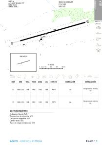
Runways:
| RWY identifier | QFU | Length (ft) | Width (ft) | Surface | LDA (ft) |
| 07 | 74° | 4818 | 75 | ASPH | |
| 25 | 254° | 4818 | 75 | ASPH |
Airport contact information
Address: Valdepenas (Ciudad Real) Spain