
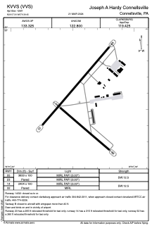


KVVS - Joseph A Hardy Connellsville
Located in Connellsville, United States
ICAO - VVS, IATA -
Data provided by AirmateGeneral information
Coordinates: N39°57'33" W79°39'27"
Elevation is 1264 feet MSL.
Magnetic variation is -08° East View others Airports in Pennsylvania
Operational data
Special qualification required
Current time UTC:
Current local time:
Weather at : KLBE - Arnold Palmer Rgnl ( 41 km )
METAR: KLBE 011655Z VRB05KT 10SM SCT110 24/08 A3020
TAF: KLBE 011720Z 0118/0218 19005KT P6SM BKN250 FM021300 21003KT P6SM VCSH BKN090 FM021700 21004KT 6SM -SHRA OVC025
Communications frequencies: [VIEW]
Runways:
| RWY identifier | QFU | Length (ft) | Width (ft) | Surface | LDA (ft) |
| 05 | 41° | 3833 | 100 | ASPH | |
| 23 | 221° | 3833 | 100 | ASPH | |
| 14 | 131° | 2404 | 100 | ASPH | |
| 32 | 311° | 2404 | 100 | ASPH |
Airport contact information
Address: Connellsville United States