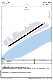


KSZP - Santa Paula
Located in Santa Paula, United States
ICAO - SZP, IATA -
Data provided by AirmateGeneral information
Coordinates: N34°20'49" W119°3'42"
Elevation is 250 feet MSL.
Magnetic variation is 14° East View others Airports in California
Operational data
Special qualification required
Current time UTC:
Current local time:
Weather at : KCMA - Camarillo ( 15 km )
METAR: KCMA 171155Z AUTO 06003KT 8SM CLR 16/11 A2972 RMK AO2 SLP073 T01560106 10183 20150 53001
TAF: KCMA 171141Z 1712/1812 VRB03KT 6SM HZ SKC FM171300 VRB03KT P6SM BKN008 FM171700 22010KT P6SM SKC FM180300 VRB03KT P6SM SKC FM180800 VRB03KT P6SM BKN008
Communications frequencies: [VIEW]
Runways:
| RWY identifier | QFU | Length (ft) | Width (ft) | Surface | LDA (ft) |
| 04 | 0° | 2665 | 60 | ASPH | |
| 22 | 0° | 2665 | 60 | ASPH |
Airport contact information
Address: Santa Paula United States

