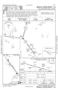
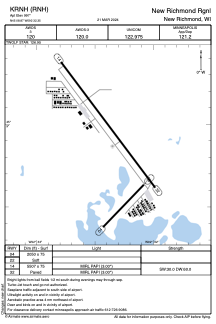


KRNH - New Richmond Rgnl
Located in New Richmond, United States
ICAO - RNH, IATA -
Data provided by AirmateGeneral information
Coordinates: N45°8'52" W92°32'21"
Elevation is 997 feet MSL.
Magnetic variation is 02° East View others Airports in Wisconsin
Operational data
Special qualification required
Current time UTC:
Current local time:
Weather
METAR: KRNH 011535Z AUTO 25004KT 10SM SCT005 BKN014 OVC031 17/16 A2997 RMK AO2 P0003 T01660158
TAF: KRNH 011126Z 0112/0212 19004KT 6SM -SHRA BR SCT005 OVC050 TEMPO 0114/0117 BKN015 FM011800 27005KT P6SM SCT025 FM012100 30004KT P6SM FEW250 FM020400 18003KT P6SM FEW250
Communications frequencies: [VIEW]
Runways:
| RWY identifier | QFU | Length (ft) | Width (ft) | Surface | LDA (ft) |
| 04 | 44° | 2050 | 75 | GRASS | |
| 22 | 224° | 2050 | 75 | GRASS | |
| 14 | 143° | 5507 | 75 | ASPH | |
| 32 | 323° | 5507 | 75 | ASPH |
Airport contact information
Address: New Richmond United States

