


KNXP - Twentynine Palms Self
Located in Twentynine Palms, United States
ICAO - NXP, IATA -
Data provided by AirmateGeneral information
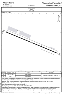
Coordinates: N34°17'46" W116°9'44"
Elevation is 2051 feet MSL.
Magnetic variation is 11° East View others Airports in California
Operational data
Special qualification required
Current time UTC:
Current local time:
Weather
METAR: KNXP 030956Z AUTO 30010KT 10SM CLR 24/04 A2986 RMK AO2 SLP073 T02390039
TAF: TAF KNXP 0309/0409 28014KT 9999 SKC QNH2972INS FM031830 30008KT 9999 SKC QNH2978INS FM032130 25001KT 9999 SKC QNH T23/0313Z T38/0323Z
Communications frequencies: [VIEW]
Runways:
| RWY identifier | QFU | Length (ft) | Width (ft) | Surface | LDA (ft) |
| 10 | 0° | 8015 | 150 | OTHER | |
| 28 | 0° | 8015 | 150 | OTHER |
Airport contact information
Address: Twentynine Palms United States