


KNKX - Miramar Mcas (Joe Foss Fld)
Located in San Diego, United States
ICAO - NKX, IATA -
Data provided by AirmateGeneral information
Coordinates: N32°52'7" W117°8'35"
Elevation is 477 feet MSL.
Magnetic variation is 12° East View others Airports in California
Operational data
Special qualification required
Current time UTC:
Current local time:
Weather
METAR: KNKX 160955Z 17004KT 4SM BR OVC008 16/15 A2976 RMK AO2 SLP073 T01610150
TAF: TAF KNKX 1609/1709 18005KT 8000 BR BKN007 QNH2975INS BECMG 1613/1615 16005KT 9999 FEW010 QNH2974INS BECMG 1702/1704 18005KT 8000 BR BKN010 QNH2976INS FM170630 VRB03KT 4800 BR OVC008 QNH2971INS T18/1615Z T26/1621Z
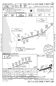
Communications frequencies: [VIEW]
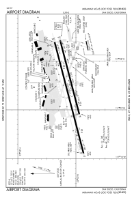
Runways:
| RWY identifier | QFU | Length (ft) | Width (ft) | Surface | LDA (ft) |
| 06L | 75° | 12000 | 200 | CONC | |
| 24R | 255° | 12000 | 200 | CONC | |
| 06R | 75° | 8001 | 200 | OTHER | |
| 24L | 255° | 8001 | 200 | OTHER |
Airport contact information
Address: San Diego United States