


KMSN - Dane County Rgnl/Truax Fld
Located in Madison, United States
ICAO - MSN, IATA - MSN
Data provided by AirmateGeneral information
Coordinates: N43°8'24" W89°20'15"
Elevation is 886 feet MSL.
Magnetic variation is -03° East View others Airports in Wisconsin
Operational data
Special qualification required
Current time UTC:
Current local time:
Weather
METAR: KMSN 030753Z AUTO 18004KT 10SM CLR 17/11 A2990 RMK AO2 SLP121 T01720111
TAF: KMSN 030529Z 0306/0406 15007KT P6SM SCT250 FM031400 17011KT P6SM BKN060 PROB30 0314/0318 6SM -TSRA BR BKN050CB FM031800 19011G19KT P6SM BKN060 PROB30 0318/0320 5SM TSRA BR BKN050CB FM032000 20010G18KT 6SM -SHRA BR BKN070 PROB30 0320/0324 4SM TSRA BR BKN030CB FM040000 20006KT P6SM BKN100 PROB30 0400/0403 5SM TSRA BR OVC030CB
Communications frequencies: [VIEW]
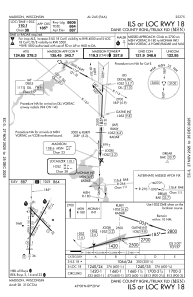
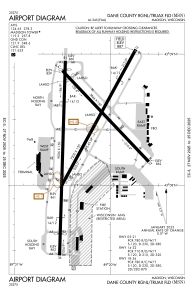
Runways:
| RWY identifier | QFU | Length (ft) | Width (ft) | Surface | LDA (ft) |
| 03 | 29° | 7200 | 150 | CONC | 6770 |
| 21 | 209° | 7200 | 150 | CONC | 7015 |
| 14 | 136° | 5846 | 150 | CONC | 5369 |
| 32 | 316° | 5846 | 150 | CONC | 5846 |
| 18 | 182° | 9006 | 150 | CONC | 8606 |
| 36 | 2° | 9006 | 150 | CONC | 8006 |
Airport contact information
Address: Madison United States
