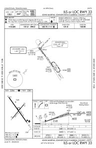
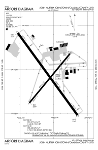


KJST - John Murtha Johnstown/Cambria County
Located in Johnstown, United States
ICAO - JST, IATA - JST
Data provided by AirmateGeneral information
Coordinates: N40°18'56" W78°50'5"
Elevation is 2284 feet MSL.
Magnetic variation is -10° East View others Airports in Pennsylvania
Operational data
Special qualification required
Current time UTC:
Current local time:
Weather
METAR: KJST 030654Z AUTO 22004KT 9SM OVC007 17/15 A3001 RMK AO2 CIG 006V011 SLP152 T01670150
TAF: KJST 030526Z 0306/0406 26005KT P6SM BKN009 OVC060 FM030800 27006KT 5SM BR BKN006 OVC015 FM031400 29006KT P6SM BKN020 FM031900 32007KT P6SM SCT040 FM040500 VRB05KT 5SM BR SKC
Communications frequencies: [VIEW]
Runways:
| RWY identifier | QFU | Length (ft) | Width (ft) | Surface | LDA (ft) |
| 05 | 39° | 4387 | 100 | ASPH | 4387 |
| 23 | 219° | 4387 | 100 | ASPH | 4387 |
| 15 | 144° | 7004 | 150 | CONC | 6698 |
| 33 | 324° | 7004 | 150 | CONC | 6484 |
Airport contact information
Address: Johnstown United States
