


KFLP - Marion County Rgnl
Located in Flippin, United States
ICAO - FLP, IATA - FLP
Data provided by AirmateGeneral information
Coordinates: N36°17'27" W92°35'25"
Elevation is 719 feet MSL.
Magnetic variation is 00° East View others Airports in Arkansas
Operational data
Special qualification required
Current time UTC:
Current local time:
Weather
METAR: KFLP 011756Z AUTO 29008KT 10SM FEW028 BKN038 24/18 A3000 RMK AO2 SLP155 6//// T02440183 10250 20183 53004 PNO $
Communications frequencies: [VIEW]
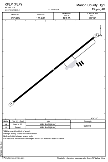
Runways:
| RWY identifier | QFU | Length (ft) | Width (ft) | Surface | LDA (ft) |
| 04 | 51° | 5001 | 75 | ASPH | |
| 22 | 231° | 5001 | 75 | ASPH |
Airport contact information
Address: Flippin United States