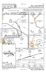
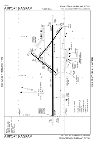


KFHU - Sierra Vista Muni-Libby Aaf
Located in Fort Huachuca Sierra Vista, United States
ICAO - FHU, IATA - FHU
Data provided by AirmateGeneral information
Coordinates: N31°35'18" W110°20'40"
Elevation is 4719 feet MSL.
Magnetic variation is 10° East View others Airports in Arizona
Operational data
Special qualification required
Current time UTC:
Current local time:
Weather
METAR: KFHU 030955Z AUTO 34004KT 10SM CLR 19/M00 A3003 RMK AO2 SLP100 T01921003
TAF: TAF KFHU 030530Z 0306/0412 24009KT 9999 SKC QNH3002INS WND VRB06KT AFT 0308 BECMG 0318/0319 22010G15KT 9999 SKC QNH2992INS TEMPO 0321/0401 25012G18KT 510005 BECMG 0401/0402 24009KT 9999 SKC QNH2994INS WND VRB06KT AFT 0408 TX33/0321Z TN14/0312Z
Communications frequencies: [VIEW]
Runways:
| RWY identifier | QFU | Length (ft) | Width (ft) | Surface | LDA (ft) |
| 03 | 37° | 4285 | 75 | OTHER | 3032 |
| 21 | 217° | 4285 | 75 | OTHER | 4285 |
| 08 | 90° | 12001 | 150 | CONC | 12001 |
| 26 | 270° | 12001 | 150 | CONC | 12001 |
| 12 | 127° | 5366 | 100 | OTHER | 5366 |
| 30 | 307° | 5366 | 100 | OTHER | 5366 |
| H1 | 0° | 0 | 0 | UNK |
Airport contact information
Address: Fort Huachuca Sierra Vista United States