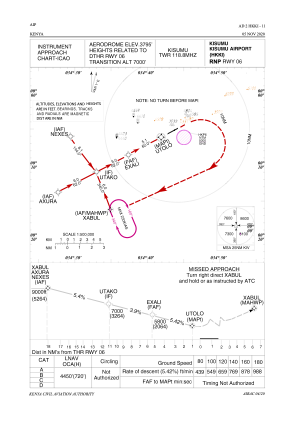


HKKI - Kisumu
Located in Kisumu, Kenya
ICAO - HKKI, IATA - KIS
Data provided by AirmateGeneral information
Coordinates: S0°5'9" E34°43'44"
Elevation is 3795 feet MSL.
Magnetic variation is 1° East View others Airports in Nyanza Province
Operational data
Special qualification required
Current time UTC:
Current local time:
Weather
TAF: TAF HKKI 290500Z 2906/3012 23010KT 9999 FEW021CB SCT022 TEMPO 2914/29 18 -TSRA FEW022CB SCT023 BKN080 BECMG 2920/2923 06005KT CAVOK BECMG 3 007/3011 24010KT FEW024CB SCT025
Communications frequencies: [VIEW]
Runways:
| RWY identifier | QFU | Length (ft) | Width (ft) | Surface | LDA (ft) |
| 06 | 62° | 9350 | 146 | ASPH | 9843 |
| 24 | 242° | 9350 | 146 | ASPH | 10312 |
Airport contact information
Address: Kisumu Kenya