

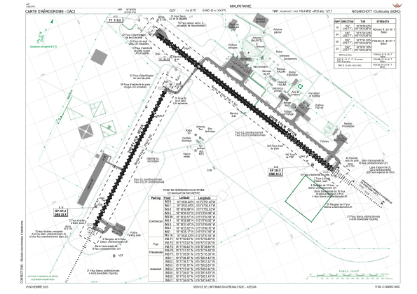


GQNO - Nouakchott-Oumtounsy
Located in Nouakchott, Mauritania
ICAO - , IATA - NKC
Data provided by AirmateGeneral information
Coordinates: N18°18'36" W15°58'11"
Elevation is 9 feet MSL.
Magnetic variation is -5° East View others Airports in Nouakchott
Operational data
Special qualification required
Current time UTC:
Current local time:
Weather
METAR: GQNO 080930Z 02019KT 4500 BLSA NSC 28/15 Q1013 TEMPO 2800 BLSA
TAF: TAF GQNO 080500Z 0806/0912 36014KT 7000 NSC PROB30 TEMPO 0809/0813 2500 BLSA
Communications frequencies: [VIEW]
Runways:
| RWY identifier | QFU | Length (ft) | Width (ft) | Surface | LDA (ft) |
| 16 | 150° | 11155 | 197 | UNK | |
| 34 | 330° | 11155 | 197 | UNK | |
| 06 | 50° | 7874 | 148 | UNK | |
| 24 | 230° | 7874 | 148 | UNK |
Airport contact information
Address: Nouakchott Mauritania

