


FAPE - Chief Dawid Stuurman International
Located in Gqeberha, South Africa
ICAO - FAPE, IATA - PLZ
Data provided by AirmateGeneral information
Coordinates: S33°59'24" E25°36'37"
Elevation is 229 feet MSL.
Magnetic variation is -28° East View others Airports in Eastern Cape
Operational data
Special qualification required
Current time UTC:
Current local time:
Weather
METAR: FAPE 052000Z 25009KT CAVOK 15/13 Q1009 NOSIG
TAF: TAF FAPE 051600Z 0518/0618 VRB03KT 9999 FEW040 TX20/0612Z TN12/0603Z BECMG 0610/0612 26016KT PROB30 TEMPO 0613/0618 26025G35KT PROB30 TEMPO 0615/0618 4500 SHRA BKN015 SCT025TCU
Communications frequencies: [VIEW]
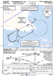
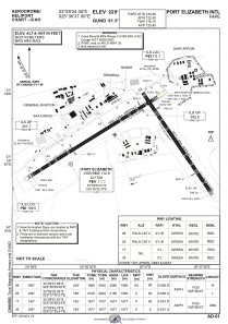
Runways:
| RWY identifier | QFU | Length (ft) | Width (ft) | Surface | LDA (ft) |
| 17 | 146° | 5487 | 145 | ASPH | 5502 |
| 35 | 326° | 5487 | 145 | ASPH | 5502 |
| 08 | 58° | 6473 | 141 | ASPH | 6496 |
| 26 | 238° | 6473 | 141 | ASPH | 6496 |
Airport contact information
Address: Gqeberha South Africa
