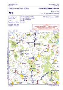
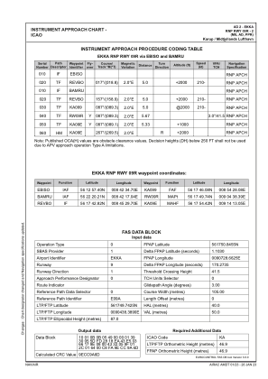
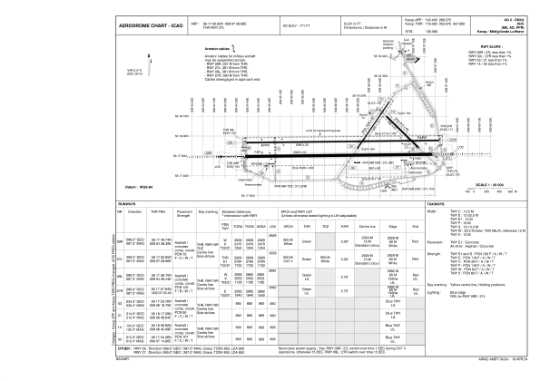


EKKA - Karup / Midtjyllands Lufthavn (Mil/Civ)
Located in Herning, Karup, Denmark
ICAO - EKKA, IATA - KRP
Data provided by AirmateGeneral information
Coordinates: N56°17'51" E9°7'29"
Elevation is 171 feet MSL.
Magnetic variation is +2.0° East View others Airports in Central Jutland
Operational data
Special qualification required
Current time UTC:
Current local time:
Weather
METAR: EKKA 290020Z AUTO 14005KT 9999 NCD 09/08 Q1012
TAF: TAF EKKA 282326Z 2900/2924 14006KT 9999 FEW200 PROB40 2900/2906 4000 BR TEMPO 2906/2912 14015G25KT 4000 RA BKN008 BECMG 2912/2914 4000 RA BKN008 BKN020CB TEMPO 2914/2916 2800 SHRA BKN020 BECMG 2916/2919 9999 NSW BKN020 TEMPO 2919/2924 4000 SHRA BKN012 SCT020CB
Communications frequencies: [VIEW]
Runways:
| RWY identifier | QFU | Length (ft) | Width (ft) | Surface | LDA (ft) |
| 03 | 0° | 2887 | 49 | UNK | |
| 21 | 0° | 2887 | 49 | UNK | |
| 14 | 134° | 2274 | 75 | PEM | |
| 32 | 314° | 2274 | 75 | PEM | |
| 09 | 90° | 2789 | 197 | GRS | |
| 27 | 270° | 2789 | 197 | GRS | |
| 09L | 89° | 9816 | 75 | ASP | |
| 27R | 269° | 9816 | 75 | ASP | |
| 09R | 89° | 9610 | 148 | PEM | |
| 27L | 269° | 9610 | 148 | PEM |
Airport contact information
Address: Herning, Karup Denmark
Web: www.krp.dk

