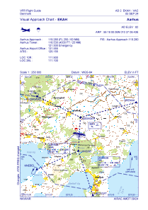
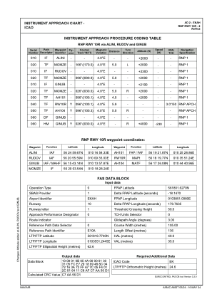
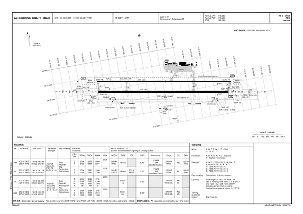


EKAH - Aarhus
Located in Aarhus, Denmark
ICAO - EKAH, IATA - AAR
Data provided by AirmateGeneral information
Coordinates: N56°18'0" E10°37'8"
Elevation is 82 feet MSL.
Magnetic variation is +1.8° East View others Airports in Central Jutland
Operational data
Special qualification required
Current time UTC:
Current local time:
Weather
METAR: EKAH 281850Z 19001KT 9999 FEW012 BKN050 14/11 Q1014
TAF: TAF EKAH 281707Z 2818/2918 24008KT 9999 BKN015 BECMG 2903/2906 14012KT TEMPO 2910/2913 BKN012 BECMG 2913/2915 BKN012 TEMPO 2915/2918 4000 RADZ BKN008
Communications frequencies: [VIEW]
Runways:
| RWY identifier | QFU | Length (ft) | Width (ft) | Surface | LDA (ft) |
| 10R | 100° | 8871 | 148 | PEM | |
| 28L | 280° | 8871 | 148 | PEM | |
| 10L | 100° | 9124 | 75 | PEM | |
| 28R | 280° | 9124 | 75 | PEM |
Airport contact information
Address: Aarhus Denmark


