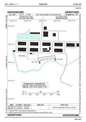


EGVH - Hereford
Located in Hereford, United Kingdom
ICAO - , IATA -
Data provided by AirmateGeneral information
Coordinates: N52°4'51" W2°47'56"
Elevation is 240 feet MSL.
Magnetic variation is -1° East View others Airports in England
Operational data
Special qualification required
Current time UTC:
Current local time:
Weather at : EGBJ - Gloucestershire ( 48 km )
METAR: EGBJ 230820Z 27009KT 230V290 9999 BKN022 13/08 Q1013
TAF: TAF EGBJ 230807Z 2309/2318 28012KT 9999 SCT025
Communications frequencies: [VIEW]
Runways:
| RWY identifier | QFU | Length (ft) | Width (ft) | Surface | LDA (ft) |
| 08 | 0° | 492 | 68 | UNK | |
| 26 | 0° | 492 | 68 | UNK |
Airport contact information
Address: Hereford United Kingdom