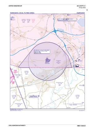


EGTF - Fairoaks
Located in Woking, United Kingdom
ICAO - EGTF, IATA -
Data provided by AirmateGeneral information
Coordinates: N51°20'53" W0°33'31"
Elevation is 80 feet MSL.
View others Airports in England
Operational data
Special qualification required
Current time UTC:
Current local time:
Weather at : EGLL - London Heathrow ( 16 km )
METAR: EGLL 042220Z AUTO 30004KT 9999 -RA OVC047 12/08 Q1011
TAF: TAF AMD EGLL 041708Z 0418/0524 25010KT 9999 BKN035 TEMPO 0418/0422 25015G25KT 8000 RA BKN014 BECMG 0420/0423 33008KT PROB30 TEMPO 0509/0515 5000 SHRA
Communications frequencies: [VIEW]
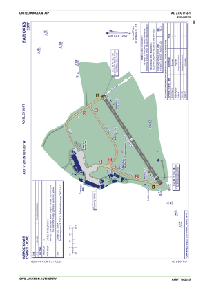
Runways:
| RWY identifier | QFU | Length (ft) | Width (ft) | Surface | LDA (ft) |
| 06 | 58° | 2657 | 89 | asphalt | |
| 24 | 238° | 2657 | 89 | asphalt |
Airport contact information
Address: Woking United Kingdom
Other aviation service providers
Flight schools

London Transport Flying Club Limited
London Transport Flying Club Limited
info@ltfc.org.uk+44 01276858502
Synergy Aviation Limited T/A Fairoaks Flight Centre
Synergy Aviation Limited T/A Fairoaks Flight Centre
info@flysynergy.com+44 08456757757