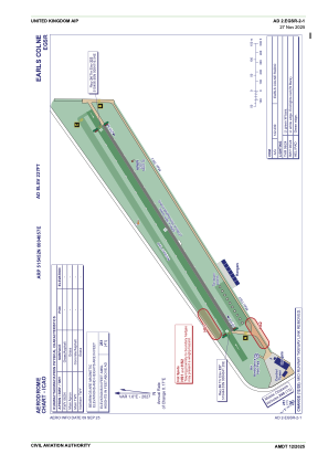


EGSR - Earls Colne
Located in Halstead, United Kingdom
ICAO - EGSR, IATA -
Data provided by AirmateGeneral information
Coordinates: N51°54'52" E0°40'57"
Elevation is 227 feet MSL.
View others Airports in England
Operational data
Special qualification required
Current time UTC:
Current local time:
Communications frequencies: [VIEW]
Runways:
| RWY identifier | QFU | Length (ft) | Width (ft) | Surface | LDA (ft) |
| 06 | 60° | 3081 | 98 | UNK | |
| 24 | 240° | 3081 | 98 | UNK |
Airport contact information
Address: Halstead United Kingdom
Other aviation service providers
Flight schools

Steve Wilkes T/A Sws Steve Wilkes Seminars
Steve Wilkes T/A Sws Steve Wilkes Seminars
info@pilotgroundschool.co.uk+44 01787269820
