IAC chart of EGNX
ADC chart of EGNX
Satellite view of EGNX
image banner adimage banner adimage banner ad
image banner ad

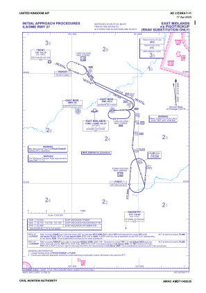
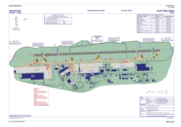
EGNX - East Midlands

Located in Derby, United Kingdom

ICAO - EGNX, IATA - EMA

Data provided by Airmate  

General information

Coordinates: N52°49'52" W1°19'40"
Elevation is 306 feet MSL.
 
View others Airports in England

Operational data

Special qualification required
Current time UTC:
Current local time:
Weather
METAR: EGNX 151850Z 19005KT 9999 VCSH SCT038 13/08 Q0998
TAF: TAF EGNX 151702Z 1518/1618 27012KT 9999 SCT040 TEMPO 1518/1524 6000 SHRA PROB30 TEMPO 1518/1521 3000 +SHRA BKN009 BECMG 1521/1524 19005KT TEMPO 1600/1608 6000 SHRA RA BKN012 PROB30 TEMPO 1600/1606 4000 +SHRA +RA BKN008 BECMG 1603/1606 27010KT PROB30 TEMPO 1612/1618 6000 SHRA
View NOTAMs / SUP AIP / TFR affecting this airport [VIEW]
Communications frequencies: [VIEW]

Runways:

RWY identifierQFULength (ft)Width (ft)SurfaceLDA (ft)
0988°9495148ASP
27268°9495148ASP

Airport contact information

Address: Derby United Kingdom

Handlers

Signature Flight Support

Signature Flight Support
[VIEW][VIEW]
+447787533659

Advantage Flight Support Ltd

Advantage Flight Support Ltd
[VIEW][VIEW]
+447876395887

Donington Aviation

Donington Aviation

Rvl Aviation

Rvl Aviation
[VIEW][VIEW]
+441332819833

Other aviation service providers

Flight schools

Donair Flying Club Limited

Donair Flying Club Limited

Looporder Limited T/A East Midlands Helicopters

Looporder Limited T/A East Midlands Helicopters

Satellite view of EGNX