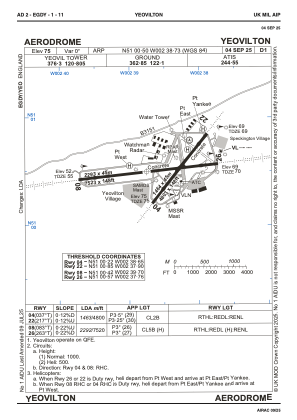


EGDY - Yeovilton
Located in Yeovil, United Kingdom
ICAO - EGDY, IATA - YEO
Data provided by AirmateGeneral information
Coordinates: N51°0'30" W2°38'44"
Elevation is 75 feet MSL.
Magnetic variation is -1° East View others Airports in England
Operational data
Special qualification required
Current time UTC:
Current local time:
Communications frequencies: [VIEW]
Runways:
| RWY identifier | QFU | Length (ft) | Width (ft) | Surface | LDA (ft) |
| 04 | 37° | 4800 | 148 | CONC | 4800 |
| 22 | 217° | 4800 | 148 | CONC | 4800 |
| 08 | 83° | 7520 | 148 | CONC | 7520 |
| 26 | 263° | 7520 | 148 | CONC | 7520 |
Airport contact information
Address: Yeovil United Kingdom
