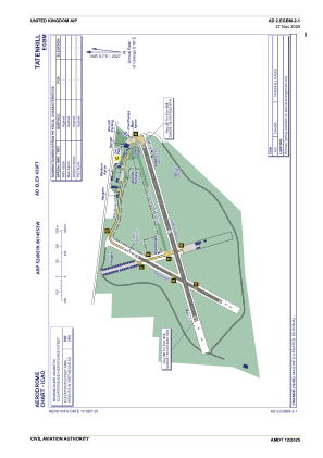


EGBM - Tatenhill
Located in Burton-On-Trent, United Kingdom
ICAO - EGBM, IATA -
Data provided by AirmateGeneral information
Coordinates: N52°48'51" W1°45'53"
Elevation is 439 feet MSL.
View others Airports in England
Operational data
Special qualification required
Current time UTC:
Current local time:
Communications frequencies: [VIEW]
Runways:
| RWY identifier | QFU | Length (ft) | Width (ft) | Surface | LDA (ft) |
| 08 | 73° | 3904 | 92 | Asphalt | |
| 26 | 253° | 3904 | 92 | Asphalt | |
| 03 | 0° | 2067 | 59 | UNK | |
| 21 | 0° | 2067 | 59 | UNK |
Airport contact information
Address: Burton-On-Trent United Kingdom
Other aviation service providers
Flight schools

Craig Padfield T/A Central Flight Training
Craig Padfield T/A Central Flight Training
info@centralflighttraining.com+44 07870578328