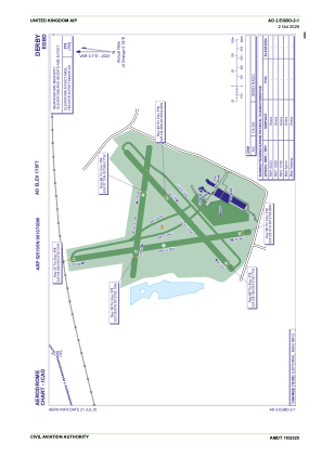


EGBD - Derby
Located in Derby, United Kingdom
ICAO - EGBD, IATA -
Data provided by AirmateGeneral information
Coordinates: N52°51'35" W1°37'3"
Elevation is 175 feet MSL.
View others Airports in England
Operational data
Special qualification required
Current time UTC:
Current local time:
Communications frequencies: [VIEW]
Runways:
| RWY identifier | QFU | Length (ft) | Width (ft) | Surface | LDA (ft) |
| 05 | 48° | 1795 | 66 | Grass | |
| 23 | 228° | 1795 | 66 | Grass | |
| 10 | 98° | 1486 | 66 | Grass | |
| 28 | 278° | 1486 | 66 | Grass | |
| 17 | 171° | 1949 | 66 | Grass | |
| 35 | 351° | 1949 | 66 | Grass |
Airport contact information
Address: Derby United Kingdom
Other aviation service providers
Flight schools

Airspeed Aviation Limited T/A Derby Aero Club & Flying School
Airspeed Aviation Limited T/A Derby Aero Club & Flying School
derbyaeroclub@btconnect.com+44 01283733803