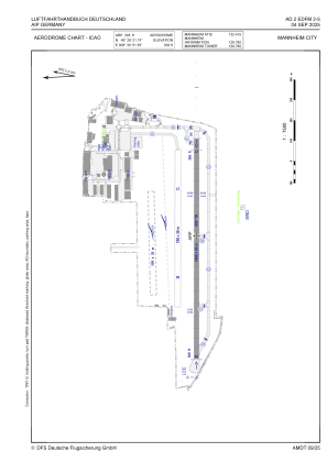


EDFM - Mannheim City
Located in Mannheim, Germany
ICAO - EDFM, IATA - MHG
Data provided by AirmateGeneral information
Coordinates: N49°28'22" E8°30'51"
Elevation is 309 feet MSL.
Magnetic variation is 2.3000° East View others Airports in Baden-Württemberg
Operational data
Special qualification required
Current time UTC:
Current local time:
Weather
METAR: EDFM 290920Z 17007KT 130V210 9999 FEW039 OVC044 17/12 Q1014
TAF: TAF EDFM 290800Z 2909/2918 19008KT 9999 BKN040 PROB40 TEMPO 2911/2918 RA
Communications frequencies: [VIEW]
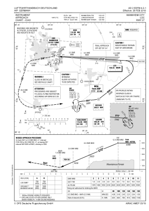
Runways:
| RWY identifier | QFU | Length (ft) | Width (ft) | Surface | LDA (ft) |
| 09 | 93° | 3497 | 82 | ASPH | 3478 |
| 27 | 273° | 3497 | 82 | ASPH | 3323 |
| 09G | 93° | 2608 | 98 | GRASS | 2119 |
| 27G | 273° | 2608 | 98 | GRASS | 1962 |
Airport contact information
Address: Mannheim Germany
Other aviation service providers
Aviation club (not for profit)

Flugschule Des Badisch-Pfälzischen Flugsportvereins E.V .
Flugschule Des Badisch-Pfälzischen Flugsportvereins E.V .