


CYVO - Val-Dor
Located in Val-D'or, Canada
ICAO - CYVO, IATA - YVO
Data provided by AirmateGeneral information
Coordinates: N48°3'12" W77°46'58"
Elevation is 1105 feet MSL.
Magnetic variation is -13.2006° East View others Airports in Quebec
Operational data
Special qualification required
Current time UTC:
Current local time:
Communications frequencies: [VIEW]
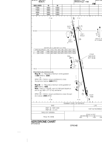
Runways:
| RWY identifier | QFU | Length (ft) | Width (ft) | Surface | LDA (ft) |
| 18 | 169° | 10000 | 150 | ASPH | 10000 |
| 36 | 349° | 10000 | 150 | ASPH | 10000 |
Airport contact information
Address: Val-D'or Canada
Other aviation service providers
Flight schools

École De Pilotage De L’abitibi-Témiscamingue Inc.
École De Pilotage De L’abitibi-Témiscamingue Inc.
richard.a.roy@epatair.com+18198252255