


CYST - St. Theresa Point
Located in St. Theresa Point, Canada
ICAO - CYST, IATA - YST
Data provided by AirmateGeneral information
Coordinates: N53°50'44" W94°51'8"
Elevation is 767 feet MSL.
Magnetic variation is 0.1983° East View others Airports in Manitoba
Operational data
Special qualification required
Current time UTC:
Current local time:
Weather at : CYIV - Island Lake ( 13 km )
METAR: CYIV 011800Z AUTO 21012G21KT 9SM CLR 19/05 A2952 RMK SLP004 DENSITY ALT 1900FT
TAF: TAF CYIV 011240Z 0113/0201 20010G20KT P6SM FEW090 FM011800 21012G22KT P6SM BKN070 BECMG 0119/0121 26015G25KT RMK FCST BASED ON AUTO OBS. NXT FCST BY 011900Z
Communications frequencies: [VIEW]
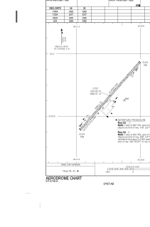
Runways:
| RWY identifier | QFU | Length (ft) | Width (ft) | Surface | LDA (ft) |
| 04 | 41° | 3391 | 75 | GRAVE | 3391 |
| 22 | 221° | 3391 | 75 | GRAVE | 3391 |
Airport contact information
Address: St. Theresa Point Canada