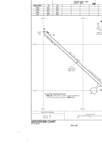


CYLU - Kangiqsualujjuaq (Georges River)
Located in , Canada
ICAO - CYLU, IATA - XGR
Data provided by AirmateGeneral information
Coordinates: N58°42'41" W65°59'34"
Elevation is 217 feet MSL.
Magnetic variation is -23.2248° East View others Airports in Quebec
Operational data
Special qualification required
Current time UTC:
Current local time:
Communications frequencies: [VIEW]
Runways:
| RWY identifier | QFU | Length (ft) | Width (ft) | Surface | LDA (ft) |
| 16 | 133° | 3521 | 100 | GRAVE | 3521 |
| 34 | 313° | 3521 | 100 | GRAVE | 3521 |
Airport contact information
Address: Canada