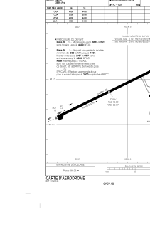


CYGV - Havre St-Pierre
Located in Havre St-Pierre, Canada
ICAO - CYGV, IATA - YGV
Data provided by AirmateGeneral information
Coordinates: N50°16'55" W63°36'40"
Elevation is 125 feet MSL.
Magnetic variation is -18.0969° East View others Airports in Quebec
Operational data
Special qualification required
Current time UTC:
Current local time:
Communications frequencies: [VIEW]
Runways:
| RWY identifier | QFU | Length (ft) | Width (ft) | Surface | LDA (ft) |
| 08 | 63° | 4498 | 100 | ASPH | 4498 |
| 26 | 243° | 4498 | 100 | ASPH | 4498 |
Airport contact information
Address: Havre St-Pierre Canada