


CYDB - Burwash
Located in Burwash, Canada
ICAO - CYDB, IATA - YDB
Data provided by AirmateGeneral information
Coordinates: N61°22'14" W139°2'24"
Elevation is 2645 feet MSL.
Magnetic variation is 18.7004° East View others Airports in Yukon Territory
Operational data
Special qualification required
Current time UTC:
Current local time:
Weather
TAF: TAF CYDB 132340Z 1400/1412 30007KT P6SM SCT050 BKN080 TEMPO 1400/1410 P6SM VCSH BKN050 FM141000 29006KT P6SM SCT050 BKN080 TEMPO 1410/1412 P6SM -SHRA SCT020 BKN050 RMK FCST BASED ON AUTO OBS. NXT FCST BY 140600Z
Communications frequencies: [VIEW]
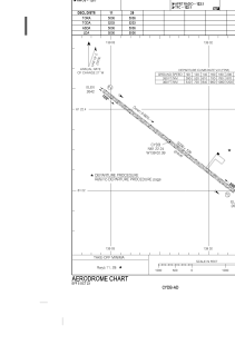
Runways:
| RWY identifier | QFU | Length (ft) | Width (ft) | Surface | LDA (ft) |
| 11 | 128° | 5006 | 100 | GRAVE | 5006 |
| 29 | 308° | 5006 | 100 | GRAVE | 5006 |
Airport contact information
Address: Burwash Canada