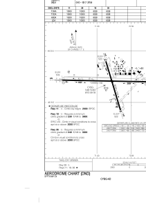


CYBG - Bagotville
Located in , Canada
ICAO - CYBG, IATA - YBG
Data provided by AirmateGeneral information
Coordinates: N48°19'50" W70°59'47"
Elevation is 522 feet MSL.
Magnetic variation is -16.401° East View others Airports in Quebec
Operational data
Special qualification required
Current time UTC:
Current local time:
Communications frequencies: [VIEW]
Runways:
| RWY identifier | QFU | Length (ft) | Width (ft) | Surface | LDA (ft) |
| 11 | 91° | 10000 | 150 | CONC | 10000 |
| 29 | 271° | 10000 | 150 | CONC | 10000 |
| 18 | 163° | 6029 | 150 | ASPH | 6029 |
| 36 | 343° | 6029 | 150 | ASPH | 6029 |
Airport contact information
Address: Canada
