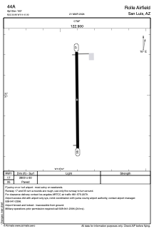


44A - Rolle Airfield
Located in San Luis, United States
ICAO - 44A, IATA -
Data provided by AirmateGeneral information
Coordinates: N32°30'59" W114°41'54"
Elevation is 163 feet MSL.
Magnetic variation is 13° East View others Airports in Arizona
Operational data
Special qualification required
Current time UTC:
Current local time:
Weather at : KNYL - Yuma Mcas/Yuma Intl ( 18 km )
METAR: KNYL 080557Z AUTO 21004KT 7SM SCT250 31/12 A2969 RMK AO2 SLP050 LAST T03110117 10406 20311 51021
TAF: TAF KNYL 0803/0903 26008KT 9999 BKN250 QNH2964INS FM080900 19004KT 9999 FEW250 QNH2969INS FM081500 18006KT 9999 SKC QNH2976INS FM082100 19010KT 9999 SKC QNH2968INS AUTOMATED SENSOR METWATCH 0406 TIL 1014 T24/0812Z T41/0823Z
Communications frequencies: [VIEW]
Runways:
| RWY identifier | QFU | Length (ft) | Width (ft) | Surface | LDA (ft) |
| 17 | 0° | 2800 | 60 | ASPH | |
| 35 | 0° | 2800 | 60 | ASPH |
Airport contact information
Address: San Luis United States