


KHEZ - Hardy-Anders Fld/Natchez-Adams County
Situé à Natchez, United States
ICAO - HEZ, IATA -
Données fournies par AirmateInformation générale
Coordonnées: N31°36'49" W91°17'50"
Élévation : 272 feet MSL.
Variation magnétique : 00° East Voir autres Aéroports à Mississippi
Données opérationnelles
Special qualification required
Heure actuelle UTC:
Heure actuelle locale:
Météo
METAR: KHEZ 030156Z AUTO 00000KT 10SM CLR 22/21 A2987 RMK AO2 SLP114 T02220206
TAF: KHEZ 022343Z 0300/0324 17006KT P6SM BKN035 OVC120 FM030500 15008KT P6SM OVC015 FM030800 16005KT 5SM BR OVC007 FM031400 19006KT P6SM OVC015 FM031600 18008KT 5SM -SHRA BR VCTS BKN018CB FM032100 19008KT P6SM VCSH BKN025 BKN035
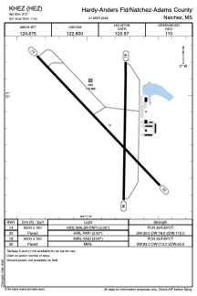
Fréquences de communication: [VIEW]
Pistes:
| Identifiant RWY | QFU | Longueur (ft) | Largeur (ft) | Surface | LDA (ft) |
| 14 | 136° | 6500 | 150 | ASPH | |
| 32 | 316° | 6500 | 150 | ASPH | |
| 18 | 181° | 5000 | 150 | ASPH | |
| 36 | 1° | 5000 | 150 | ASPH |
Coordonnées de l'aéroport
Adresse: Natchez United States