


KSAT - San Antonio Intl
Situé à San Antonio, United States
ICAO - SAT, IATA - SAT
Données fournies par AirmateInformation générale
Coordonnées: N29°32'2" W98°28'9"
Élévation : 809 feet MSL.
Variation magnétique : 04° East Voir autres Aéroports à Texas
Données opérationnelles
Special qualification required
Heure actuelle UTC:
Heure actuelle locale:
Météo
METAR: KSAT 312251Z 03010KT 10SM FEW050 FEW250 29/17 A2996 RMK AO2 SLP126 T02940172
TAF: KSAT 312059Z 3121/0124 VRB03KT P6SM SCT025 BKN040 FM010000 05006KT P6SM SCT050 FM010900 04006KT P6SM BKN025 FM011200 05006KT P6SM BKN012 FM011800 09007KT P6SM BKN030
Fréquences de communication: [VIEW]
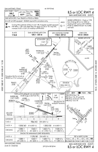
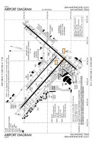
Pistes:
| Identifiant RWY | QFU | Longueur (ft) | Largeur (ft) | Surface | LDA (ft) |
| 04 | 41° | 8505 | 150 | CONC | 8505 |
| 22 | 221° | 8505 | 150 | CONC | 8505 |
| 13L | 132° | 5519 | 100 | ASPH | 5519 |
| 31R | 312° | 5519 | 100 | ASPH | 5519 |
| 13R | 132° | 8502 | 150 | CONC | 8502 |
| 31L | 312° | 8502 | 150 | CONC | 8502 |
Coordonnées de l'aéroport
Adresse: San Antonio United States
Autres services d'aviation
Écoles de pilotage

Alpha Tango Flying Services, Inc.
Alpha Tango Flying Services, Inc.
alpha.tango@sbcglobal.net2108284480