


KICT - Wichita Dwight D Eisenhower Ntl
Situé à Wichita, United States
ICAO - ICT, IATA - ICT
Données fournies par AirmateInformation générale
Coordonnées: N37°38'60" W97°25'59"
Élévation : 1332 feet MSL.
Variation magnétique : 04° East Voir autres Aéroports à Kansas
Données opérationnelles
Special qualification required
Heure actuelle UTC:
Heure actuelle locale:
Météo
METAR: KICT 011553Z VRB03KT 10SM FEW010 BKN025 BKN070 23/19 A2998 RMK AO2 SLP139 T02330189 $
TAF: KICT 011414Z 0114/0212 VRB03KT 5SM BR BKN012 TEMPO 0114/0115 5SM BR BKN005 FM011500 00000KT P6SM BKN020 FM011600 00000KT P6SM BKN060 FM012000 14004KT P6SM SCT090 FM020600 12007KT P6SM BKN100
Fréquences de communication: [VIEW]
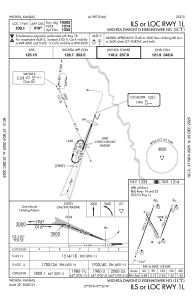
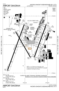
Pistes:
| Identifiant RWY | QFU | Longueur (ft) | Largeur (ft) | Surface | LDA (ft) |
| 01L | 20° | 10302 | 150 | CONC | 10301 |
| 19R | 200° | 10302 | 150 | CONC | 10301 |
| 01R | 20° | 7302 | 150 | CONC | 7302 |
| 19L | 200° | 7302 | 150 | CONC | 7302 |
| 14 | 150° | 6301 | 150 | CONC | 6301 |
| 32 | 330° | 6301 | 150 | CONC | 6301 |
Coordonnées de l'aéroport
Adresse: Wichita United States

