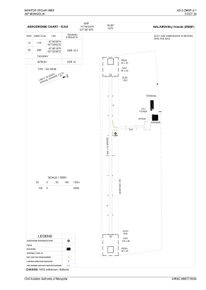


ZMSF - Nalaikh/Sky Friends
Located in Nalaikh, Mongolia
ICAO - , IATA -
Data provided by AirmateGeneral information
Coordinates: N47°46'23" E107°26'16"
Elevation is 4829 feet MSL.
View others Airports in Ulanbaatar
Operational data
Special qualification required
Current time UTC:
Current local time:
Weather at : ZMUB - Ulaanbaatar/Buyant-Ukhaa ( 51 km )
METAR: ZMUB 040200Z VRB01MPS CAVOK 09/M05 Q1014 NOSIG RMK QFE653.4 37
TAF: TAF ZMUB 032245Z 0400/0506 VRB02MPS 9999 SCT033 TX21/0407Z TN08/0423Z BECMG 0406/0408 FEW030CB BKN033 TEMPO 0412/0503 VRB09G14MPS SHRA SCT027CB SCT030 BECMG 0422/0424 14010MPS
Communications frequencies: [VIEW]
Runways:
| RWY identifier | QFU | Length (ft) | Width (ft) | Surface | LDA (ft) |
| 12 | 112° | 0 | 0 | UNK | |
| 30 | 292° | 0 | 0 | UNK |
Airport contact information
Address: Nalaikh Mongolia