


YWVA - Warnervale
Located in Wyong, Australia
ICAO - YWVA, IATA -
Data provided by AirmateGeneral information
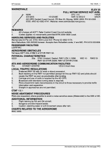
Coordinates: S33°14'28" E151°25'45"
Elevation is 30 feet MSL.
Magnetic variation is 12° East View others Airports in New South Wales
Operational data
Special qualification required
Current time UTC:
Current local time:
Weather at : YWLM - Williamtown ( 62 km )
METAR: YWLM 011030Z AUTO 35003KT 9999 // SCT022 BKN045 BKN056 16/14 Q1029 RESHRA
TAF: TAF AMD YWLM 010524Z 0106/0206 17014KT 9999 -SHRA BKN030 FM011000 28008KT 9999 -SHRA BKN030 FM020000 16012KT 9999 -SHRA BKN040 INTER 0106/0115 3000 SHRA BKN010 INTER 0115/0206 4000 SHRA BKN012
Communications frequencies: [VIEW]
Runways:
| RWY identifier | QFU | Length (ft) | Width (ft) | Surface | LDA (ft) |
| 02 | 0° | 3914 | 33 | Grass | |
| 20 | 0° | 3914 | 33 | Grass |
Airport contact information
Address: Wyong Australia
