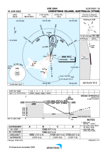
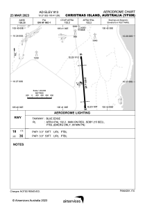


YPXM - Christmas Island
Located in Christmas Island, Christmas Island
ICAO - YPXM, IATA - XCH
Data provided by AirmateGeneral information
Coordinates: S10°27'2" E105°41'25"
Elevation is 916 feet MSL.
View others Airports in (unassigned)
Operational data
Special qualification required
Current time UTC:
Current local time:
Weather
METAR: YPXM 050230Z AUTO 14013KT 9999 // BKN019 BKN025 OVC030 27/24 Q1013
TAF: TAF YPXM 042308Z 0500/0600 11012KT 9999 BKN015 INTER 0500/0502 1000 SHRA BKN002 TEMPO 0500/0502 9999 BKN010 TEMPO 0512/0600 9999 BKN010
Communications frequencies: [VIEW]
Runways:
| RWY identifier | QFU | Length (ft) | Width (ft) | Surface | LDA (ft) |
| 18 | 175° | 6900 | 148 | ASP | |
| 36 | 355° | 6900 | 148 | ASP |
Airport contact information
Address: Christmas Island Christmas Island