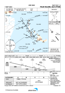
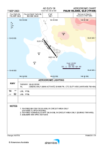


YPAM - Palm Island
Located in Palm Island, Australia
ICAO - YPAM, IATA - PMK
Data provided by AirmateGeneral information
Coordinates: S18°45'19" E146°34'53"
Elevation is 30 feet MSL.
View others Airports in Queensland
Operational data
Special qualification required
Current time UTC:
Current local time:
Weather at : YBTL - Townsville / Townsville Intl ( 59 km )
METAR: YBTL 271930Z AUTO 14008KT 9999 // BKN029 BKN037 BKN046 23/20 Q1016
TAF: TAF YBTL 271729Z 2718/2818 16008KT 9999 -SHRA SCT020 BKN025 FM280100 11018KT 9999 NSW SCT025 FM280900 16008KT 9999 SCT020 INTER 2718/2803 3000 SHRA BKN010
Communications frequencies: [VIEW]
Runways:
| RWY identifier | QFU | Length (ft) | Width (ft) | Surface | LDA (ft) |
| 14 | 143° | 3730 | 59 | COP | |
| 32 | 323° | 3730 | 59 | COP |
Airport contact information
Address: Palm Island Australia