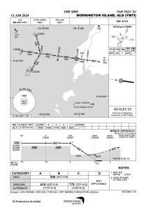
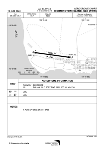


YMTI - Mornington Island
Located in Mornington Island, Australia
ICAO - YMTI, IATA - ONG
Data provided by AirmateGeneral information
Coordinates: S16°39'45" E139°10'41"
Elevation is 33 feet MSL.
View others Airports in Queensland
Operational data
Special qualification required
Current time UTC:
Current local time:
Weather at : - ( 0 km )
METAR: CYZE 280944Z AUTO 30008KT 9SM BKN013 BKN071 BKN100 06/05 A2996 RMK SLP153
Communications frequencies: [VIEW]
Runways:
| RWY identifier | QFU | Length (ft) | Width (ft) | Surface | LDA (ft) |
| 09 | 98° | 4970 | 98 | PER | |
| 27 | 278° | 4970 | 98 | PER |
Airport contact information
Address: Mornington Island Australia